1876 Print Colby Iron Works, Lanesboro, MA from Berkshire County Atlas
$24.00
1876 Map of Richmond, MA, from Beers Atlas of Berkshire County, original
$47.00
1874 Map of Fairview, Losantville, Emmetsville, Saratoga, West Lynn, Indiana
$42.00
1870 Map of Butler, Ohio, with family names, from Atlas of Columbiana County
$53.00
1876 Business Notices by town from Atlas of Berkshire County
$24.00
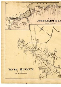
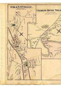
1876 map Medfield village, West Quincy, Jerusalem Rd, Franklin, MA, w/fam names
$45.00
1874 Map of White River, Indiana, with family names, from Atlas of Randolph Cty
$47.00
1878 Lamoille County, Vermont, Business Notices from Beers' Atlas - interesting!
$28.00
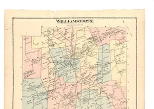
1877 map of Williamstown, Vermont from Atlas of Orange County, with family names
$51.00
1882 Map of Shirley & Sebec villages, Maine, from the Atlas of Piscatquis County
$27.00
1870 map of Brimfield, Mass. from Atlas of Hampden County, with family names
$45.00
1876 Map of Florida, Massachusetts & Adams, from Beers atlas, w/family names
$43.00
1908 Map Anna township, Illinois, from Atlas of Union County w/family names-rare
$45.00
1908 Map north part Union twn, Illinois, from Atlas of Union County w/fam. names
$51.00
1881 map Devereux, Beddington, Cherryfield (Township No. 11), Deblois, Maine
$38.00
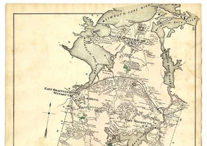
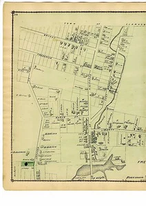
1876 map town of Weymouth, North Weymouth, Franklin village, w/family names
$45.00
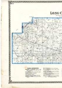
1874 Map of Long Creek & Maroa, Illinois, from Macon County atlas w/familynames
$51.00
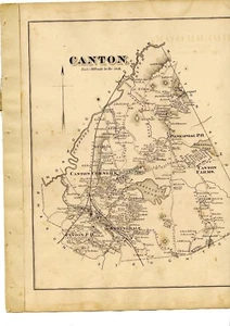
1876 maps Canton, Massachusetts, from Norfolk County Atlas, with family names!
$45.00
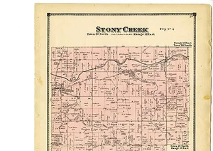
1874 Map of Stony Creek, Indiana, with family names, from Atlas of Randolph Cty.
$47.00
1908 Map south part Union twn, Illinois, from Atlas of Union County w/fam. names
$45.00
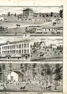
1874 Engravings of Macon County Illinois locations, from Atlas of Macon County
$29.00
1870 map of Tolland, Mass. from Atlas of Hampden County, with family names
$45.00
1908 Map of Preston, Illinois, from Atlas of Union County w/family names - rare
$45.00
Rare 1870 Map of Madison, Ohio, with family names, from Columbiana County atlas
$32.00
1876 Map of Stoughton, from Comstock & Cline atlas, with family names - Original
$47.00
1874 Map of Wayne, Indiana, with family names, from Atlas of Randolph County
$43.00
1874 Map of Washington, Indiana, with inset of Lynn, from Atlas of Randolph Cty.
$47.00
1882 Map of Medford, Maine, from the Atlas of Piscatquis County w/family names
$27.00
1876 Map of part of North Adams, Berkshire County, MA from Beers Atlas Page 25
$42.00
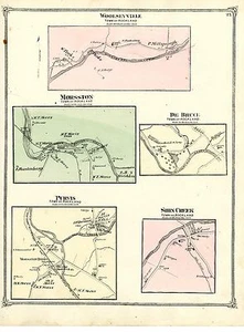
1875 Rockland villages map from Atlas of Sullivan County NY: Purvis Morsston etc
$38.00
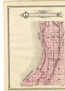
Rare 1870 Map of Homeworth, Bayard, Maysville, Franklin Square, New Garden, Ohio
$42.00
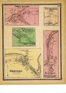
1870 map Three Rivers, Tennyville, Blanchardville, Thorndike, Duckville, MA
$45.00
1870 map of Holyoke South West Section, Mass. from Atlas of Hampden County
$45.00
1877 Map of Pennsylvania by H. W. Hopkins, C.E.
$27.00
1908 Map villages of Union County Illinois w/family names and local history info
$51.00
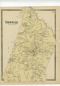
1871 Map of Conway, Mass. from Franklin County Atlas w/family names - original
$27.00
1870 map of Blandford, Mass. from Atlas of Hampden County, with family names
$45.00
vintage photos of Lyle, Serviss and Glazier family members
$15.99
1870 Map of Fairfield, Ohio, with family names, from Atlas of Columbiana County
$42.00
1871 Beers Map of Heath, w/inset maps Heath centre & Rowe centre, Beers original
$27.00
Original 1872 Map - Yonkers, New York from Beers County Atlas of Westchester p25
$47.00
1871 Beers Map of Shelburne, from Atlas of Franklin County, Mass, w/family names
$37.00
Illustrated Historical Atlas Map Carroll County, Missouiri, 1876 (reprint, 1971)
$29.00
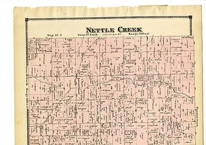
1874 Map of Nettle Creek, Indiana with family names, from Atlas of Randolph Cty
$43.00
1876 Beers map of Pontoosuc Bel Air Wahconah Berkshire County MA
$36.00
1876 map East Weymouth, Foxborough, North Weymouth, Lovells Cor. w/family names
$44.00
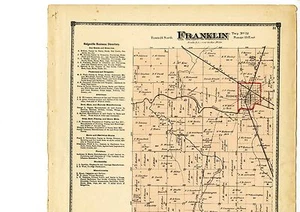
1874 Map of Franklin, Indiana, with family names, from Atlas of Randolph County
$53.00
1876 Map of part of North Adams, Berkshire County, Massachusetts from Atlas
$53.00
About us
Antique maps of towns and villages showing the property owners names. Cadastral maps of towns in Massachusetts, Connecticut, Rhode Island, Maine, Vermont, New Hampshire and New York.
Location: United StatesMember since: Jul 31, 1997Seller: oldmapsne
very nice seller, excellent packing job and fast shipping, highly recommend!!
l***2 (225)- Feedback left by buyer.
More than a year ago
Verified purchase
Super fast shipping! Great item and great seller. Packaging was fantastic, thank you for shipping flat with protective covering rather than rolled in a tube.
-***a (181)- Feedback left by buyer.
More than a year ago
Verified purchase
Great seller. Accommodating. Clear communicator. Item shipped quick & safely.