
MapHatter

25K items sold
921 followers
Contact

All items

Authentic 1928 Pictorial Map by L. Price ~ FRIGID, TEMPERATE & TROPIC ZONES

$18.000 bids2d 17h 29m

Authentic 1928 Pictorial Map by L. Price ~ A FANTASIE MAP - COMPASS, CASTLES

$18.000 bids2d 15h 5m

1888 Map ~ MICHIGAN - WISCONSIN ~ Authentic Cram Atlas Map ~(13x25)Free S&H-#059

$24.000 bids16h 45m

1892 PLUMAS - LASSES - MODOC - SIERRA Counties, CALIFORNIA Map (14x22) -#P190

$45.956% off

Old 1846 Dower's Atlas Map ~ THE EASTERN HEMISPHERE of the WORLD (9x11) -#206

$20.686% off

Authentic 1928 Pictorial Map by L. Price ~ NORTH AMERICA - SOUTH AMERICA -

$18.000 bids2d 16h 49m

1873 Plat Map ~ MOUNT AUBURN & CAMBRIDGE CEMETERY ~ CAMBRIDGE, MA (17x29) #015

$48.000 bids3d 12h 28m

1893 Map ~ NEBRASKA ~ Authentic Atlas Map ~ (11x13)Free S&H-#038

$24.000 bids15h 45m

1888 Map ~ MICHIGAN & WISCONSIN ~ Authentic Atlas Map (13x25) ~Free S&H-#023

$27.156% off

1871 Plat Map ~ ROCKTON Twp., BELOIT CITY, WINNEBAGO Co., ILLINOIS ~(15x17)-#010

$45.956% off

1896 Map ~ SIOUX FALLS, SOUTH DAKOTA ~ Authentic Atlas Map (11x13)Free S&H-#027

$32.000 bids19h 7m

1875 Plat Map, BASIL, SUGAR GROVE, OHIO / RUSHVILLE, WATERLOO on Reverse #015

$45.956% off

1876 Plat / County Map ~ GRANT Co., INDIANA ~ MARTON, UPLAND, HARRISBURG, JALAPA

$34.000 bids1d 16h 20m

1887 Plat Map KICKAPOO - LINWOOD Twp., LEAVENWORTH Co., KANSAS ~ TONGANOXIE #021

$34.000 bids1d 17h 56m

1873 Plat Map ~ MOUNT AUBURN, BRATTLE & CONCORD St. - CAMBRIDGE, MA (14x17)-#001

$48.000 bids2d 14h 17m

1896 Map ~ VACINITY of PHILADELPHIA, PENNSYLVANIA ~ (11x13)Free S&H-#037

$24.000 bids19h 52m

1893 Map ~ INDIANA ~ Authentic Atlas Map ~ (11x13) Free S&H-#034

$24.000 bids15h 36m

1915 Plat Map ~ VANCE Twp., / FAIRMOUNT, VERMILION Co., ILLINOIS (15x17)-#011

$45.956% off

Old 1897 Map of the WORLD - Authentic Atlas Map (XXL22x29) Free S&H #001

$30.916% off

1874 Plat Map ~ MANCHESTER, ONTARIO Co., NEW YORK (12x15) #017

$34.000 bids3d 15h 29m

1882 Plat Map ~ PHILADELPHIA, 27th WARD - Mt. MORIAH CEMETERY (XXL18x28) #001

$34.000 bids1d 15h 48m

1835 Star Chart ~ THE NORTHERN CIRCUMPOLAR MAP for EACH MONTH by Burrett -#021

$45.956% off

1910 Plat Map MINER, CIRCLEVILLE, WINKEL, LILLY, TAZEWELL Co., IL (XL17x29)-#020

$34.000 bids15h 59m

1875 Map ~ ARIZONA & NEW MEXICO TERRITORIES - (14x17)-#024

$45.956% off

1866 Map ~ TEXAS - GALVESTON BAY ~ Mitchell Atlas Map (12x15)-#017

$188.006% off

1876 Plat Map VERSAILLES, RIPLEY Co., INDIANA / SWITZERLAND Co. on Reverse

$45.956% off

1892 SANTA BARBARA - VENTURA - ORANGE Counties, CALIFORNIA Map (14x22) -#P197

$45.956% off

1952 Pictorial Map EGYPT - SUDAN, AFRICA ~ Illus. by Charles Pont - Vernon Quinn

$18.000 bids2d 14h 29m

1896 Map ~ MINNEAPOLIS & St. PAUL ~ (11x13)Free S&H-#062

$24.000 bids21h 52m

1874 Plat Map ~ VICTOR Twp., FISHERS, ONTARIO Co., NEW YORK (15x23) #001

$34.000 bids3d 17h 15m

1887 Plat Map ~ BURLINGAME, KANSAS / OSAGE - KARVEY Co. on Reverse #211

$45.956% off

1887 Map ~ FLORIDA ~ Authentic Mitchell Atlas Map (12x15)-#005

$45.956% off

1871 Cowperthwait Atlas Railroad Map of the UNITED STATES ~(10x11) ~#166

$18.000 bids2d 18h 17m

Dated 1886 ~ WISCONSIN - RAILROAD & TOWNSHIP MAP (17x27) -#007

$45.956% off

Authentic 1928 Pictorial Map by L. Price ~ NEW ZEALAND - NORTH & SOUTH ISLAND

$18.000 bids2d 16h 51m

Old 1890 Plat Map ~ CITY of BEAVER DAM (SOUTH), DODGE Co., WISCONSIN (Lg17x28)

$45.956% off

1901 Plat Map ~ MASCOUTAH Twp., St. CLAIR Co., ILLINOIS (17x29)-#020

$45.956% off

1875 Map ~ Louisville, Kentucky ~ Authentic O.W. Gray Atlas Map (14x17)-#013

$45.956% off

1875 Plat Map ~ PLEASANT VALLEY, LODI Twp., ATHENS Co., OHIO ~ (14x16)-#003

$45.956% off

1865 Map AMERICAN SOUTHWEST TERRITORIES Authentic Johnson Atlas Map (18x27)-#011

$34.001 bid2d 15h 39m

1889 Map ~ KANSAS ~ (XL17x23) Colored - Good Condition - Free S&H -#013

$45.956% off

1871 Plat Map ~ ROCKTON - ROSCOE, WINNEBAGO Co., ILLINOIS ~(15x17)-#011

$45.956% off

1892 MARIPOSA - FRESNO - MONA - INYO Counties, CALIFORNIA Map (14x22) -#P194

$45.956% off

1910 Plat Map ~ HOPEDALE Twp., TAZEWELL Co., Illinois (15x17)-#011

$34.000 bids15h 47m

1896 Map ~ BUFFALO, NEW YORK ~ Authentic Atlas Map (11x13)Free S&H-#035

$24.000 bids19h 47m

1865 Map ~ MARYLAND - DELAWARE ~ Authentic Johnson Atlas Map (14x18)-#002

$34.000 bids2d 14h 23m

1887 Plat Map COFFEYVILLE - INDEPENDENCE, KANSAS / MONTGOMERY Co on Reverse #177

$45.126% off

1910 Plat Map ~ MORTON Twp., TAZEWELL Co., ILLINOIS (20x17)-#033

$34.001 bid16h 49m

About us

Welcome to my eBay Store. Please add me to your list of favorite sellers and visit often. Thank you for your business.
Location: United StatesMember since: Nov 22, 2007Seller: maphatter

Store policies

Shipping

Detailed seller ratings

Average for the last 12 months

Accurate description
5.0
Reasonable shipping cost
5.0
Shipping speed
4.9
Communication
5.0

Seller feedback (8,838)

4***a (1421)- Feedback left by buyer.
Past month
Verified purchase
Good description, good price, fast shipping, good communication, great seller. Thank you
t***m (27)- Feedback left by buyer.
Past 6 months
Verified purchase
Item was as pictured and described. Packaged well. Shipped reasonably fast enough. Was originally shipped the wrong thing but the seller made it right. I definitely recommend this seller. A+++
k***3 (4054)- Feedback left by buyer.
Past 6 months
Verified purchase
Quick Shipping-Great Communication-Item arrived as described and well packaged-Very Pleased with seller-Recommended-A+++
k***3 (4054)- Feedback left by buyer.
Past 6 months
Verified purchase
Quick Shipping-Great Communication-Item arrived as described and well packaged-Very Pleased with seller-Recommended-A+++
n***o (128)- Feedback left by buyer.
Past month
Verified purchase
Seller is fair on prices. Shipping was timely and packaging was good. Will be buying more from them.
a***o (38)- Feedback left by buyer.
Past 6 months
Verified purchase
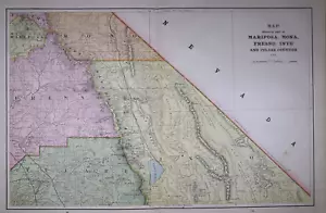
Accurately described, well packaged, really nice vintage map. I'd buy from this vendor again. My only feedback for the vendor -- it is cut out of an atlas (standard for this kind of map) and it came with a BEAUTIFUL map of Sacramento printed on the back; I didn't see any indication of the back details, but I'm treating that as a nice bonus instead of an issue.